South Fork Fire Burned Area Emergency Response (BAER) Report - July 2024
Lincoln National Forest | US Department of Agriculture
INTRODUCTION
The South Fork and Salt fires, which ignited on June 17, 2024, burned 17,066 and 7,688 acres, respectively, significantly impacting Lincoln National Forest. The Burned Area Emergency Response (BAER) program assessed the damage, focusing on soil burn severity, hydrology, and critical values such as human safety, roads, recreation sites, and cultural resources. Collaborative efforts with various agencies aim to mitigate post-fire risks and support recovery.
Maps Gallery
Fire Background
The South Fork and Salt fires ignited on Mescalero Apache lands on June 17, 2024, and rapidly spread into the Smokey Bear Ranger District of the Lincoln National Forest. The South Fork fire consumed 17,066 acres, while the Salt fire burned 7,688 acres. Of these, 5,843 acres were National Forest System (NFS) lands, with the South Fork fire affecting 5,822 acres and the Salt fire affecting just 18 acres. This report focuses on the South Fork fire due to its significant impact on NFS lands.
Burned Area Emergency Response (BAER) Program
While many wildfires cause minimal land damage, some necessitate special measures to mitigate post-fire impacts. The BAER program aims to identify and manage these risks to protect human life, safety, property, and critical natural or cultural resources. The BAER team, comprising Forest Service and Bureau of Indian Affairs (BIA) experts, conducted field assessments from June 22 to 26, 2024, to evaluate the soil burn severity and inventory critical values.
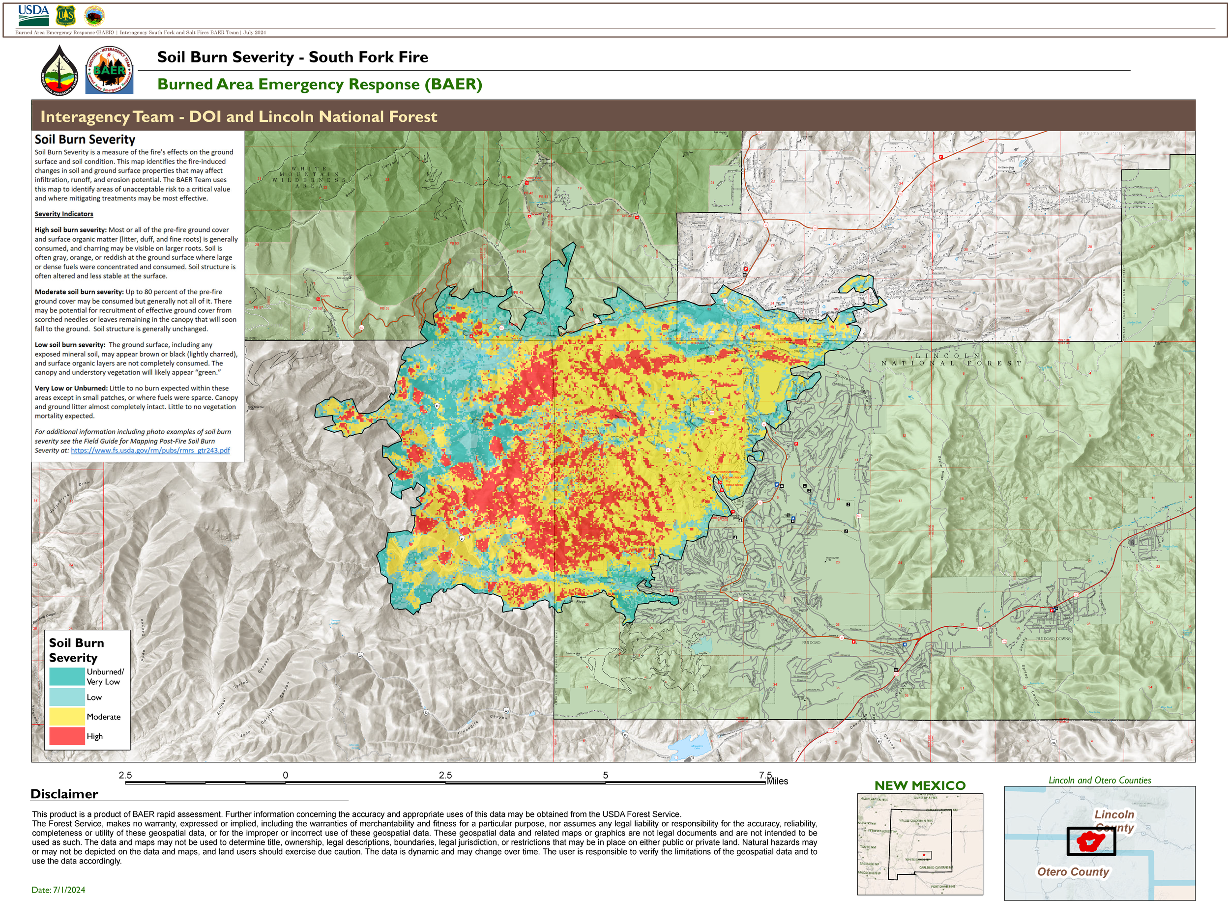
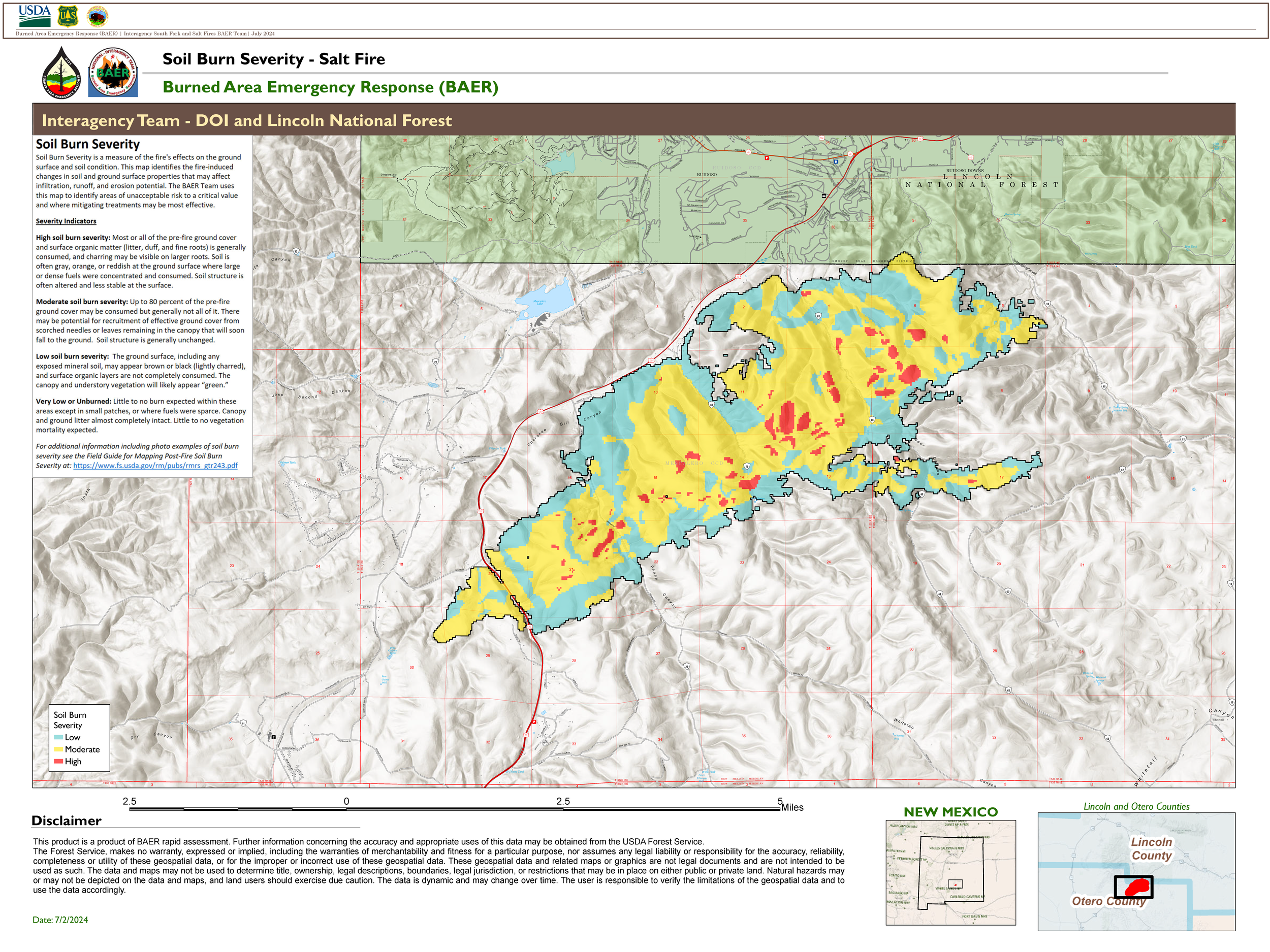
Soil Burn Severity (SBS)
Soil burn severity assesses soil condition post-fire, factoring in vegetation loss, soil structure changes, and infiltration capacity. SBS maps, created using ESRI ArcGIS software and satellite imagery, help predict erosion potential and runoff changes. The South Fork fire's SBS distribution is as follows:
High: 20%
Moderate: 46%
Low: 23%
Very Low/Unburned: 11%
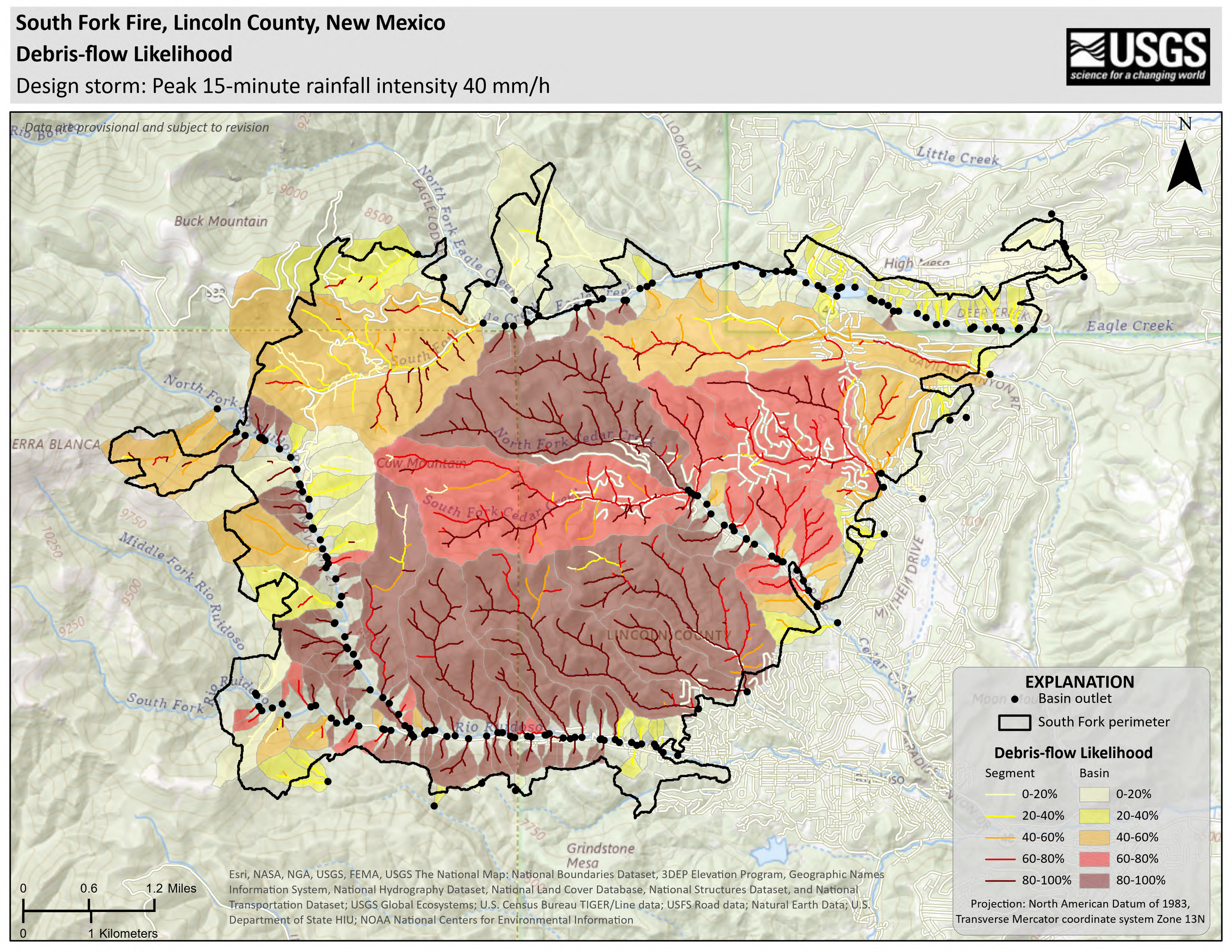
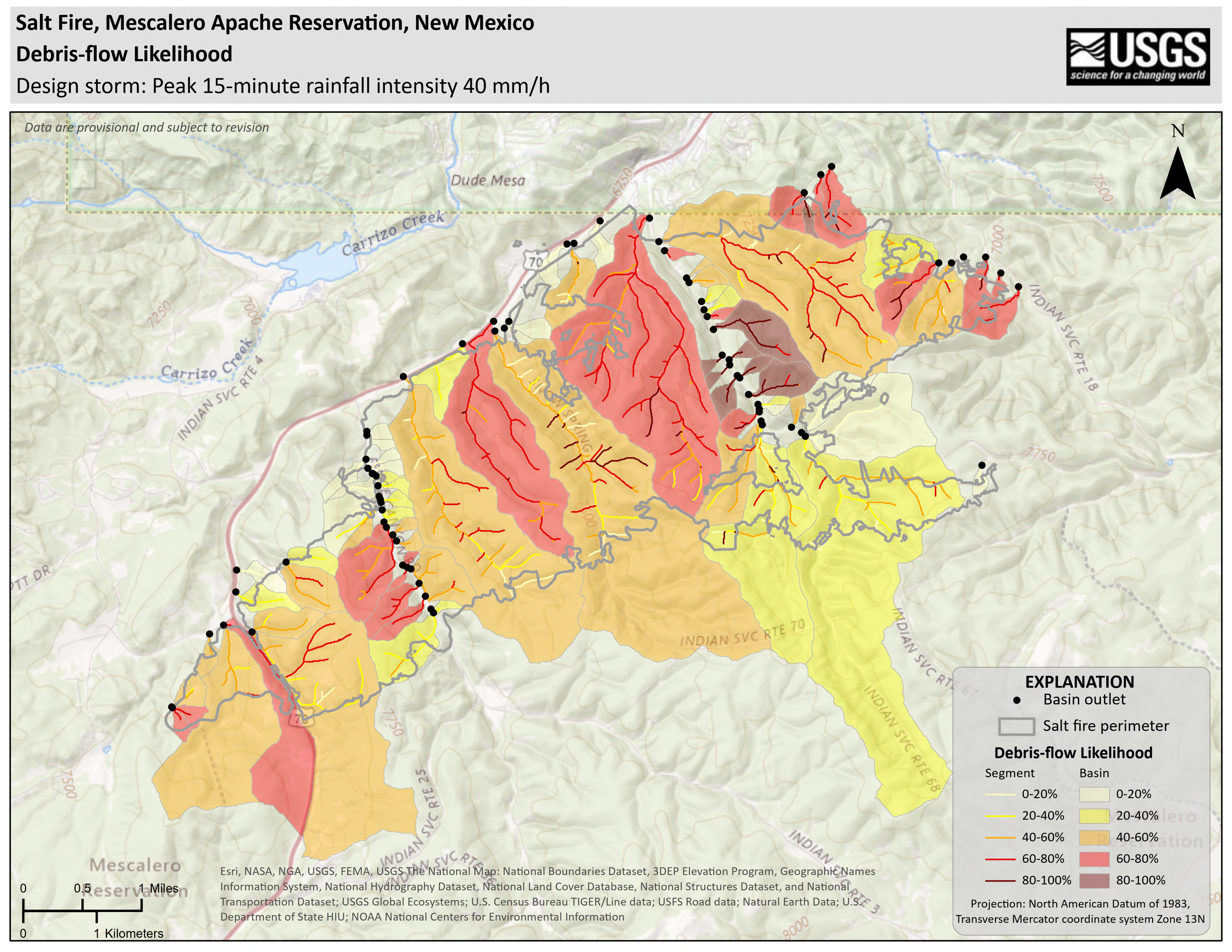
Hydrology
Post-fire watershed responses include initial flushes of ash and debris, erosion in drainages and steep slopes, increased peak flows, and sediment transport. These responses are heightened with the first rainstorms post-fire, increasing flash flood risks for at least two years. The likelihood of significant flooding events has dramatically increased in areas with high to moderate SBS, such as Cedar and Perk Canyons.
Critical Values
The BAER team's primary concern is human life and safety. Heavy rainstorms pose threats to Forest Service employees, visitors, and road users within and downstream of the burned areas. Early warning systems and general warning signs are recommended to mitigate these risks.
Roads and Bridges
Roads in and near burned areas face clogging risks from debris, potentially causing significant damage. Measures like debris rack protection and large debris removal upstream can reduce these threats. Specific stabilization treatments are proposed for Forest Service Road 127A to prevent roadway failure.
Recreation
Recreation sites like Sam Tobias Group Campground, Oak Grove Campground, and Cedar Creek Picnic Area experienced fire damage. Emergency treatments include facility safety work and cleaning. Trail drainage stabilization in the Cedar Creek area is also recommended.
Non-Native Invasive Plant Species
Invasive species like musk thistle threaten native plant communities post-fire. Early Detection and Rapid Response (EDRR) measures are recommended to monitor and treat new infestations, particularly in areas disturbed by suppression activities.
Cultural Resources
Cultural sites are at risk from erosion and falling trees. Treatments include hand seeding with high-elevation seed mixes and using biodegradable erosional fabrics to stabilize soils and protect artifacts. Monitoring will assess the effectiveness of these treatments.
Federally Listed Species - Wildlife and Fisheries
The South Fork fire affected habitats critical to species like the Mexican spotted owl. Aerial seeding and mulching are proposed to protect these habitats and support vegetation recovery.
Anticipated Vegetation Recovery
Recovery varies based on climate, vegetation types, and burn severity. Typical recovery spans 3-5 years, but persistent drought can delay this timeframe. Early signs of recovery have been noted in low-severity burn areas.
Partner Agencies
Post-fire emergency response is a collaborative effort involving multiple agencies:
Mescalero Apache Tribe
New Mexico Energy and Natural Resources Department, Forestry Division, Capitan District
Lincoln County Office of Emergency Services (OES)
Village of Ruidoso
Natural Resource Conservation Service (NRCS)
Conclusion
The BAER team's rapid assessment identified imminent threats to critical values due to the South Fork fire. While treatments cannot prevent all impacts, the Forest Service will continue providing information and working with partners to address these threats. For more information, visit the South Fork and Salt Fires Burned Area Emergency Response Information page on InciWeb (wildfire.gov).
Contacts:
Jason Freeman, Forest Supervisor: jason.freeman@usda.gov
Jennifer Thomas, Smokey Bear District Ranger: jennifer.r.thomas@usda.gov
Rhonda Stewart, Wildlife/Fisheries/T&E/BAER Staff: rhonda.stewart@usda.gov
References: Parson, A., Robichaud, P.R., Lewis, S.A., Napper, C., & Clark, J.T. (2010). Field Guide for Mapping Post-Fire Soil Burn Severity. U.S. Department of Agriculture, Forest Service, Rocky Mountain Research Station. Link to guide.
Stay informed and prepared for potential increased runoff events. For updates and detailed information, refer to the South Fork and Salt Fires Burned Area Emergency Response Information on InciWeb.